
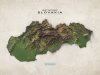
Scrotum and Totem: Phallic Cartography 101
“The Canal & River Trust is a British charity tasked with managing 2,000 miles (3,200 km) of inland waterways in England and Wales. Peddling pictures of male genitalia to the general public decidedly isn’t part of its core business. And yet there it is, sans pudeur ni morale: a village-sizedschlong dressed up as a tourist map, care of the Canal & River Trust. How did this happen? ”
Find out at BigThink.com
Related Posts


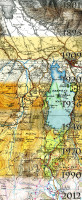


![Logashkino, Siberia in 6 different locations from 1939-1969.
[[MORE]]“How to lie with maps” talks about how the Soviets would move around the location of military bases on maps.
This is one small village (now abandoned) and the river near it and how...](https://64.media.tumblr.com/1729a8686b346ca28b578bad56c5731e/tumblr_o3nn5t7P0U1rasnq9o1_100.jpg)


