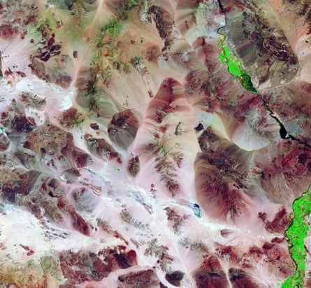
Numerous mountain ranges create valleys, salt pans, seasonal lakes and closed basins throughout the Mojave desert, US. Agriculture, appearing bright green in the image, has been hindered in recent years due to a severe drought throughout the region.
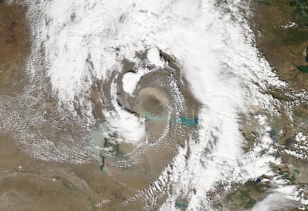
A spiralling dust storm engulfs Aktau city, eastern Kazakhstan. Whirling clouds surround an arc of tan dust north of Lake Balkhash. The storm is fed by the sand from the 250-mile-long Saryeski-Atyrau desert, stretching south from the lake and between the Ili (west) and Karatal (east) rivers. The Ili-Balkhash basin is a unique ecosystem which covers 154,000 square miles. Lake Balkhash is central Asia’s second largest, and has become shallower and more saline, with water level declining since 1960.
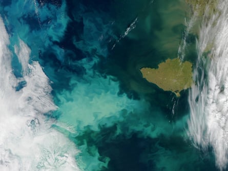
Phytoplankton blooms colour the Bering Sea aqua off the Nnivak Island on the Alaska coast. In spring, the blooms spread feeding on nutrients and fresh water from melting ice in the surface waters. In summer, they decline after exhausting nutrients or being eaten by ocean grazers. By autumn, however, storms and cooler water allow nutrients to rise to the surface again, fuelling more blooms.
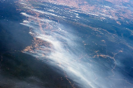
Several fires burn in the Amazon rainforest, along Brazil’s main highway BR 163. Fires are set to clear patches of forest for agriculture, revealing red-brown soils. A long line of newly cleared patches snakes east from BR 163 towards the remote valley of Rio Crepori. Extensive deforested areas in Mato Grosso state appear in tan across the top of the image. Fires show deforestation extending into the state of Pará, which has second highest deforestation acreage after Mato Grosso.
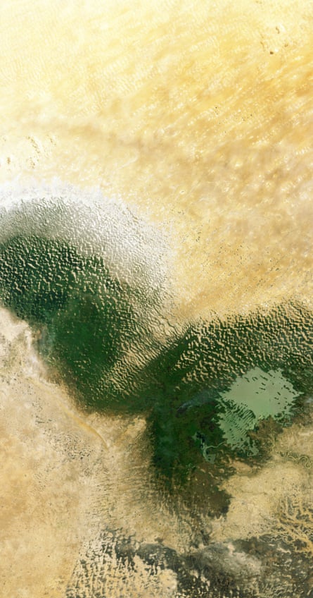
Lake Chad in west Africa’s Sahel region creates a transition zone between the Sahara desert to the north and savannahs and woodlands to the south. The lake is the main source of fresh water for over 60m people in Chad, Cameroon, Niger and Nigeria. It is also the main source for the region’s irrigation, drinking water for livestock, fishing and supports a rich biodiversity. The lake is fed by the Chari and Logone rivers, flowing into it from southwest. Despite seasonal fluctuations, the surface of the lake has changed enormously in the past decades, with high losses from the 1960s to 1980s, mainly due to a reduction of precipitation induced by climate change, as well as an increased human demand for water. But recent assessments indicate rainfall and subsequent flooding of the surrounding wetlands is filling up the lake since 2004.
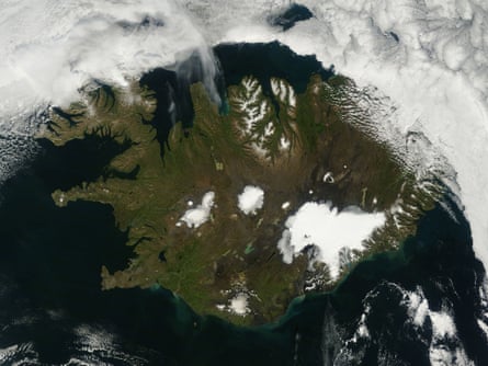
A sunny summer day over Iceland reveals green vegetation and snow-capped rugged northern peaks. Further south the glaciers, including Vatnajökull, the largest in Europe and the site of Iceland’s highest mountain, Hvannadalshnúkur, appear bright white. On 29 August, a short-lived eruption occurred north of Vatnajökull glacier, followed by another the next day which continued unabated till last week. There has been no significant explosive activity, but lava continues to flow. High concentrations of sulphuric gases produced by volcanic eruptions are primary health concern.
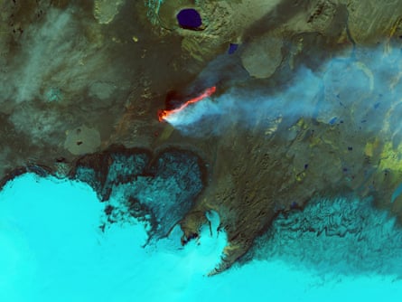
A bright orange flame smokes over Iceland’s Holuhraun lava field as the Bardarbunga and Askja volcanoes erupt. This infrared image shows ice, and steam and sulfur dioxide plume, cyan and bright blue, water navy blue, bare or rocky ground around the lava field appears green or brown and fresh lava bright orange and red. Holuhraun has spewed more lava this month than any Icelandic volcano since the 19th century. Till last week the lava flow was 10-mile long and covered about eight square miles.
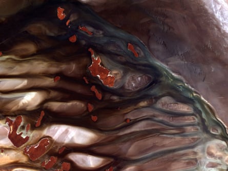
The Lake Gairdner national park, containing nearby lakes Everard and Harris, was established in 1991 for its signicant wildlife habitat and natural features. It remains hot and dry in summer, but spring brings water and turns it into a a popular destination for birdwatchers. When flooded, Gairdner is one of the largest salt lakes in Australia, more than 99-mile long and 30-mile wide. But when dry, the vast salt pan attracts racers attempting to set land speed records and is the site for the annual Speed Week event. This image shows mostly the dry, salt-crusted lakebed, while the islands appear brick-red.
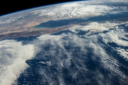
Although land and waters of Mexico’s Pacific area pictured here are influenced by masses of clouds, for Baja California and other parts of Mexico, things are quite calmer than a few days ago when hurricane Odile unleashed its power on the peninsula, especially Baja’s south end (right side of frame) and Cabo San Lucas (just out of frame right). The Sea of Cortez (Gulf of California) experiences rather calm weather in this view. California’s Salton Sea is visible at left centre; and Guadalupe Island is visible at lower left, surrounded by von Karman vortices.
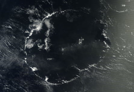
Clouds come in all shapes, even in near perfect circles, like this one over the Hawaiian Islands. While circular clouds can form in several situations, this formation likely began when the sun heated air over a small island or patch of warm ocean water. As the warm air became buoyant and rose, cumulus clouds and eventually patches of light rain probably developed. The rain would have cooled the air beneath the clouds, causing a downdraft that sent rain-cooled air outward from the original location of the clouds. When the rain-cooled air encountered warmer air at the edge of the cell, it likely pushed the warm air up, which caused the ring of cumulus clouds to form.
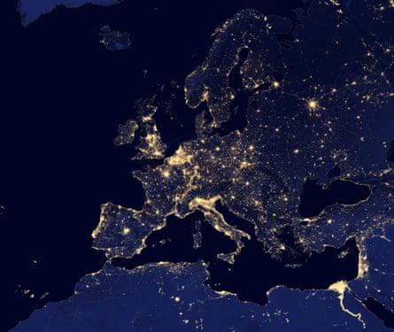
Night view of Europe and North Africa seen in a global composite assembled from satellite data. The Visible Infrared Imaging Radiometer Suite (VIIRS) detects light in a range of wavelengths from green to near-infrared and uses filtering techniques to observe dim signals such as city lights, wildfires, and gas flares.
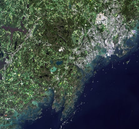
Finland’s capital and largest city, Helsinki (upper right), on the shores of the Gulf of Finland. Situated on the tip of a peninsula and on more than 300 islands, Helsinki is sparsely populated compared to other European capitals and has many green areas. Running north to south through the centre of the city is a six-mile-long forested park that offers opportunities for outdoor sports and activities to residents. This year, the park celebrates its centenary, marked by various activities including nature walks, a photo competition and other events. Above, in the north of the city we can see the runways of the Helsinki airport, while farther west, the large, dark green area is Nuuksio national park.
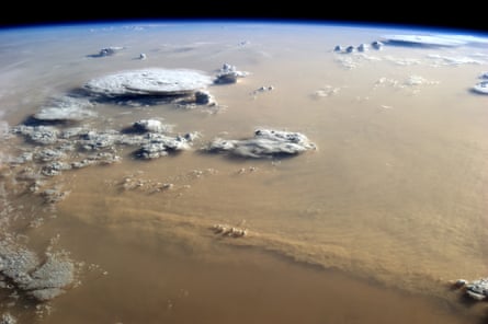
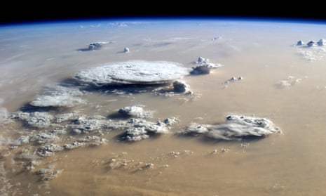
More dust blows out of the Sahara into the atmosphere than from any other desert in the world, and more than half of the dust deposited in the ocean lifts off from these arid north African lands. Saharan dust influences the fertility of Atlantic waters and soils in the Americas. It blocks or reflects sunlight and affects the formation of clouds. By way of the dry Saharan air layer, dust either promotes or suppresses the development of Atlantic hurricanes, an enigma that scientists are trying to sort out. In the picture above, taken over Libya, a storm stretches for hundreds of kilometers across the sand seas of the Sahara. Winds appear to be coming out of the east or northeast (left), and the sun is setting to the west (right in the image). Billowing clouds suggest a cold, windy front moving across the desert, perhaps a haboob (intense dust storm). The African land surface is blocked from view by the thick dust; even the clouds are half obscured.
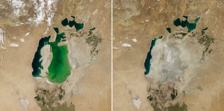
Summer 2014 marked another milestone for the Aral Sea. The once-extensive lake has been shrinking since the 1960s. And for the first time in modern history, its eastern basin dried out completely. The images above—August 2014 (right) and August 2000—show a stark contrast in its extent. In the 1950s and 1960s, Soviet Union government diverted the Amu Darya and the Syr Darya—the region’s two major rivers—to irrigate farmland. The diversion began the lake’s gradual retreat. By 2000, the lake had already separated into the north (small) Aral Sea in Kazakhstan and the south (large) Aral Sea in Uzbekistan. The south had further split into western and eastern lobes. The eastern lobe nearly dried in 2009 and then saw a huge rebound in 2010. Water levels have continued to fluctuate annually in alternately dry and wet years.
