
Fifty years ago this week, the Great Alaska Earthquake ravaged the Pacific Northwest, killing more than 100 people. Nine-tenths of those weren’t caused by the earthquake, though, but by a series of tsunamis that pummeled the coast, one of which towered 219 feet (66 meters) high.
They come taller than that, though. The 1958 tsunami that ripped through Lituya Bay, a sleepy fjord near the Gulf of Alaska, was eight times bigger. And though its causes make it different from the far-traveling waves that slammed Southeast Asia in 2004 or Japan in 2011, the warming of the atmosphere will make both types become more common.
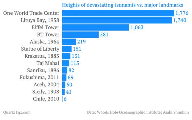
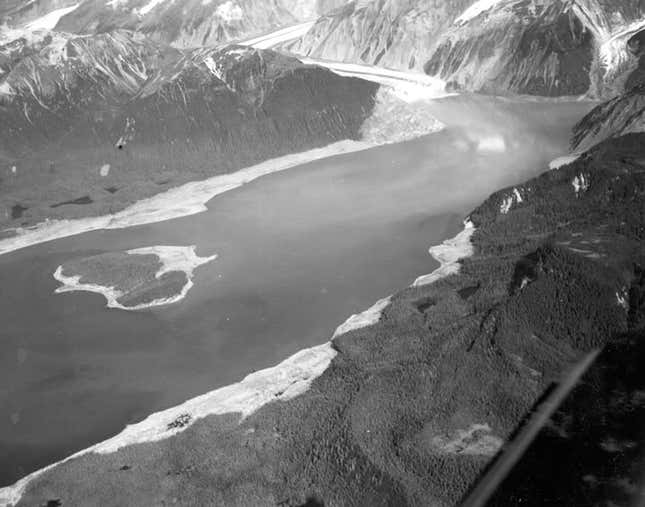
Calamity struck at 10pm on July 9, 1958, when a 8.0-Richter-scale earthquake rammed the Alaskan coast up and northward. That impact shook free between 40 million and 60 million cubic yards (30.6 million and 46 million cubic meters) of rock and ice that rimmed the Lituya basin, dumping it 3,000 feet into the bay below. The 1,720-foot monster that reared up as a result shot through the bay at 100 miles per hour (161 kilometers per hour), as Susan Casey details in her book, The Wave: In Pursuit of the Rogues, Freaks and Giants of the Ocean. Here’s how it worked:
Amazingly, four people survived. They were split between one boat that powered directly up the face of the still-building wave, and another that rode it like a surfer about 80 feet above the treetops, until being dumped into the Gulf of Alaska in a hail of uprooted trees.
Flanked by ledges of ice and rock—and close to a fault lively enough to dislodge them and cause avalanches—Lituya Bay’s topography is uniquely lethal. Geologists say that a 492-foot wave hit (paywall; pdf, p.155) in 1936, and a 394-footer in 1853. French and Russian explorers met nasty ends there, according to Casey (one christened the middle island “Cenotaph,” which means a monument to the dead.) And then there’s the story Casey retells of a Tlingit Indian woman who returned from a day of berry-picking to find her entire village swept away, the corpses of her clan strewn among the remaining trees.
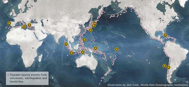
Most tsunamis in historical record start differently, though. Volcanic rumblings and shifting tectonic plates cause undersea earthquakes. When those quakes force enough land upward, they displace huge ripples of water that grow into tsunamis. The Ring of Fire—the volcanic ridge that curls around the Pacific Ocean—is the planet’s most seismically active, generating 80% of the world’s earthquakes—which is why so many tsunamis slam into Japan and Chile. Landslides, both underwater and above, can create huge waves like Lituya’s; earthquakes are usually, though not always, responsible.
A warming climate ups the chance of both types. Melting glaciers redistribute weight across the planet and the related pressure bends the sea floor, increasing volcanic activity.
In fact, that’s what happened at the end of the last ice age, as Casey explains. Though it’s impossible to know exactly how that changed the seas, scientists have some clues—for instance, the undersea landslide off Norway about 7,900 years ago. The resulting tsunamis were only 32-64 feet (pdf). Still, those waves swallowed up a big enough chunk of the coast of the Netherlands, Germany, and Denmark that they helped turn Britain into an island.