Make the most of the mild weather while it lasts!
The unseasonable warmth we're experiencing is soon to be replaced by a brisk chill with temperatures plunging next week when more snow is expected in parts of the UK.
Thankfully, Coventry and Warwickshire will escape the most extreme weather systems with daytime highs dropping to around 7C, though a widespread frost is forecast next Monday into Tuesday.
Read More: UK and world news
Freezing Arctic winds are due to be the dominant feature in the UK's weather by the end of the weekend with WXCharts showing the mercury could drop to -11C in parts of Scotland next week.
From November 24, snow is expected to fall in the Grampians and the Highlands before moving down the country and by the end of the month it is likely to cover parts of northern England and North Wales.
Places as far south as Brighton could have sub zero temperatures by November 27 according to the weather maps.

Oliver Claydon, from the Met Office, told the Express : "Long-lead models are showing there is a chance for things to turn a bit colder in the middle of next week.
"Uncertainty is hinged around an area of high pressure, if it’s further to the west then it could pull a chance of snow from the north."
Snow is likely to continue after next week and temperatures will get colder as the month goes on.
James Madden, forecaster for Exact Weather, told the Express : "The cold is likely to win out before the end of November bringing an early taste of winter and the risk of snow.

"Waning solar activity means chances are high for a 'little ice age' winter this year with notable periods of cold and snow.
"We have high confidence for the most cold and wintry conditions since December 2010 developing towards the end of the year."
That could bring extreme cold temperatures and spells of widespread snow, he added.
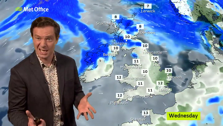
Met Office five-day UK weather forecast
Tuesday
Mostly cloudy start across England and Wales with possible drizzle, and patchy thick fog in the east and south. Sunnier breaks further north and west, before Scotland and Northern Ireland see rain followed by blustery, heavy showers. Windy and colder.
Weakening rain band crossing southern UK followed by clearer conditions. Further north, blustery showers, some heavy, especially for northern and western Scotland, wintry on higher hills. Windy and chilly here.
Wednesday
Showers in northern and western areas will slowly ease, although replaced by evening rain in northwest UK. Further south, a mainly dry day with sunny spells. Somewhat cooler and breezier.
Thursday to Saturday
Most regions dry and very mild with variable, often large amounts of cloud. Rain across the far northwest sinking further south on Saturday and turning colder from the north.
Keep up with the latest news with our email alerts directly to your inbox. Sign up here